Photos from Malawi


| Home | About | Guestbook | Contact |
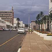
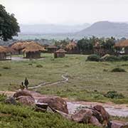
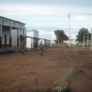
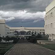
MALAWI - 1975
|
A short history of Malawi
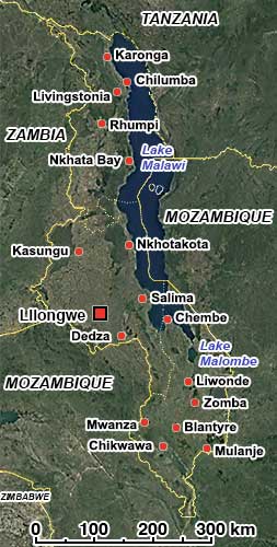
The Republic of Malawi, formerly known as Nyasaland, in the southeast of Africa, is a landlocked country of around 118,484 km², with a population of 19.5 million. It shares a border with Zambia to the west, Tanzania to the north and northeast, and Mozambique to the east, south and southwest. Malawi’s capital and largest city is Lilongwe; its former capital, until 1974, was Zomba, now the fourth-largest city.
This part of Africa only had small populations of hunter-gatherers until the 10th century CE, when waves of Bantu peoples started emigrating from the Congo basin in the north. Although most of those continued their migration further south, some remained, and by around the year 1480, the various tribes had settled around Lake Malawi and to its south, in the valley of the Shire River. They established the Kingdom of Maravi, reaching from the present town of Nkhotakota in the north to the Zambezi River in the south, including parts of Mozambique and Zambia. “Maravi” refers to the peoples who lived in this area, while the similar-sounding “Malawi” apparently derives from “malaŵí,” meaning “flames” in Chichewa (Nyanja), the primary language from the kingdom and now the main language of Malawi.
After 1600, Portuguese traders appeared, and by 1700, the kingdom had broken up into separate ethnic regions. In the mid-1800s, the East African slave trade was at its height; around 20,000 people were enslaved per year, transported from Nkhotakota to Kilwa and the slave markets in Zanzibar, in present-day Tanzania, where they were sold. In 1859, the Scottish missionary and explorer David Livingstone reached Lake Malawi (then called Lake Nyasa). He considered the plateau of the Shire Highlands south of the lake an area ideal for promoting Christianity and commerce. Several Anglican and Presbyterian missions were established in the area in the 1860s and 1870s, and a small mission and trading settlement was established at Blantyre in 1876.
In 1889, John Buchanan, deputy of Henry Hamilton Johnston, the British consul to Mozambique and the Interior, proclaimed, against foreign office orders, a protectorate over the Shire Highlands to forestall further incursions by the Portuguese (who also coveted the area). Shortly after that, Johnston declared a second protectorate without foreign office approval over territories to the area west of the lake: the Nyasaland Districts Protectorate. In 1891, an Anglo-Portuguese treaty ended over 20 years of increasing disagreement over conflicting territorial claims in the eastern part of Central Africa; it fixed the borders, and the British Central Africa Protectorate was proclaimed over the whole area of present-day Malawi. That same year, slavery came to an end. In 1907, the protectorate was renamed Nyasaland.
In 1953, Britain combined Nyasaland with Northern and Southern Rhodesia (present-day Zambia and Zimbabwe): the Federation of Rhodesia and Nyasaland, often called the Central African Federation (CAF). The linking caused opposition from African nationalists: in 1944, they had formed the Nyasaland African Congress (NAC) to promote local interests to the British government and Dr Hastings Banda, a European-trained doctor working in Ghana, was an influential opponent of the Federation. He returned to Nyasaland in 1958, was elected president of the NAC and promoted the nationalist cause. The colonial authorities jailed him in 1959, but he was released the following year and asked to help draft a new constitution for Nyasaland.
Banda’s Malawi Congress Party (MCP) got most of the votes in elections for a Legislative Council, and Hastings Kamuzu Banda became Prime Minister in 1963. The same year, the Federation of Rhodesia and Nyasaland was dissolved, and on 6 July 1964, Nyasaland became independent from British rule, renaming itself Malawi. Two years later, on 6 July 1966, it became a republic under a new constitution, with Banda as its first president and his MCP as the only legal party. In 1971, Banda was declared president-for-life, and for almost 30 years, he presided over a rigidly totalitarian and one of the most repressive regimes in Africa, with political opponents regularly tortured and murdered. Banda was the subject of an extensive cult of personality; strict dress codes were in place, with women not allowed to wear skirts or dresses that went above the knees and men’s hair no longer than collar length; even tourists were given mandatory haircuts at the airport.
In 1993, under pressure for greater political freedom, Banda finally agreed to a referendum; people voted for a multi-party democracy. The same year, a presidential council was formed, the life presidency was abolished, and a new constitution was adopted, effectively ending the MCP’s rule. The following year, 1994, multi-party elections were held, and Bakili Muluzi, a former Banda Cabinet Minister, defeated Banda. On 18 May 1995, the constitution was changed again, and Malawi became a unitary presidential republic composed of three regions (the Northern, Central, and Southern regions).
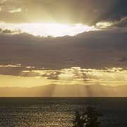
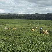
Malawi’s population is 85% rural, and its economy is based on agriculture. It is one of Africa’s most beautiful and compact countries. It has much to offer: wildlife, culture, adventure, scenery, and, of course, the third-largest lake in Africa. It is a year-round destination, and some visitors have even described it as the most attractive destination in Africa!