Photos from South Eastern Australia


SOUTH AUSTRALIA, FROM OUTBACK TO BEACH
|
|
A short profile of South Australia
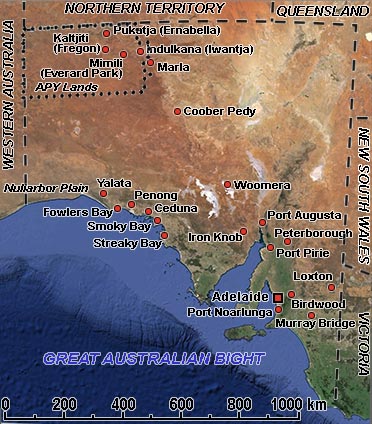
South Australia, in the southern central part of the country, covers some of the most arid parts of the continent. Uniquely, it shares borders with all mainland states and the Northern Territory. The state has a total land area of 983,482 km² and, with over 1.6 million people, less than 8% of the total Australian population. Most of its people live in the state capital, Adelaide, with most remaining settled in fertile areas along the southeastern coast and the River Murray. The official settlement of South Australia began on 28 December 1836, when Governor John Hindmarsh proclaimed the colony. The first settlement to be established was Kingscote on Kangaroo Island in July 1836, five months before Adelaide was founded.
Situated south of the Northern Territory, the northern part of this state is a continuation of the arid plains and hills of the NT. The Anangu (Aboriginal) people, too, are the same as the Pitjantjatjara and Yankunytjatjara, living in the settlements of Pukatja (Ernabella), Kaltjiti (Fregon), Mimili, Indulkana, Amata and Pipalyatjara are related to the people of the region of Uluru, or Ayers Rock. Ernabella started as a Presbyterian mission in the forties but has now, as everywhere, its own council; Mimili, described as the site of “Maku” or “witchetty grub” dreaming, was initially named “Everard Park” by Europeans when it was a cattle station. However, it was always called “Mimili” by the Anangu.
Further south, the landscape gradually changes and becomes more lush; here is the Murray River, Australia’s longest river; there are wine-growing areas and the beautiful capital of Adelaide. On the Spencer Gulf, Port Pirie is the site of the world’s most significant silver, lead and zinc smelter, and Port Augusta is an important regional commercial and administrative centre. In the southwest, towards the Western Australian border, are scenic lonely bays like Fowlers Bay, now the site of a ghost town, slowly buried by the encroaching sands, and Smoky Bay, named by the explorer Matthew Flinders for the smoke of the cooking fires of the local Aborigines. And in Loxton, on the Murray River near the border with Victoria, is the “Pioneer Village”, celebrating the settlers that opened up this country.