Photos from Western Australia


WESTERN AUSTRALIA, AUSTRALIA’S LARGEST STATE
 s
sA short profile of Western Australia
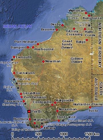
Australia’s largest state occupies the western third of the continent and has an area of 2,525,500 km² with a population of over 2.5 million. It stretches from the temperate region around Perth in the south to the remote coast of the Kimberley in the north, from the cold waters in the Great Australian Bight to the “hottest town in the country”, Marble Bar in the Pilbara region. There are ancient meteorite craters and forests of Karri trees, among the tallest in the world. As it says on the number plates, it is indeed a “State of Excitement”.
The Western Plateau, covering most of the state, is a shield of ancient rock with an elevation generally between 230 and 460 metres. There are three climatic regions in Western Australia: the southwest, with warm to hot, dry summers and mild, rainy winters; the hot, monsoonal northern fringe; and the vast interior, hot and arid. Near the coasts, annual rainfall averages 635 mm, but most of the interior receives less than 255 mm. The capital, Perth, is located on the southwest coast, where more than 90 % of the people live. The Aboriginal population lives mainly in the vast and sparsely populated outback region.
It is accepted that the first Aboriginal people arrived from the north between 40,000 and 60,000 years ago and were well-established throughout the region. The Dutch explorer Dirk Hartog was the first European to set foot on the coast of Western Australia on 25 October 1616; the site, now named Inscription Bay, is on the largest island off the Western Australian coast, Dirk Hartog Island, 850 kilometres north of Perth. He gave the Australian mainland the name “Eendrachtsland” after his ship, the “Eendracht” (Unity). Other navigators followed, usually without intention; many ships were wrecked on the coast. The most famous shipwreck was that of the “Batavia”, a vessel of the Dutch East India Company (VOC) that, on its maiden voyage, was wrecked on Morning Reef near Beacon Island on 4 June 1629, followed by mutiny and massacre that took place among the survivors. Two men were left on the mainland, and there are suggestions the local people adopted them as later visitors reported some unusually light-skinned Aborigines in that area.
The British started exploring the Western Australian coast late 18th century, and in 1826 they established a military outpost at King George Sound, near present-day Albany; this was followed three years later by the Swan River Colony, where Perth now stands. It is the only Australian colony that was never a part of New South Wales. It was formally created on 18 June 1829 when the hitherto unclaimed portion of the Australian continent (west of longitude 135° E) was annexed by the United Kingdom. The first inland settlement, York, 97 kilometres east of Perth, was established in September 1831. The following year there were 1,500 settlers in the colony, and its name was changed to Western Australia. Gold was discovered around Kalgoorlie in the 1890s, and this brought more settlers. In 1890 the act granting self-government to the colony was passed by the British Parliament, and on 1 January 1901, it became a state in Australia’s federation.