Photos from Victoria


VICTORIA, AUSTRALIA’S SMALLEST MAINLAND STATE
|
|
A short profile of Victoria
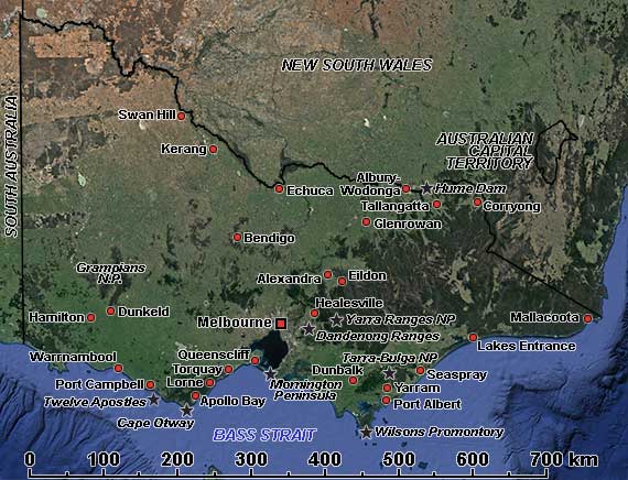
Although less than 3% of the total land area of Australia, the southeastern state of Victoria has a quarter of its population; settlement by whites started in 1830, and in the 1850s, gold attracted many settlers. Victoria’s Aboriginal population, estimated at around 30,000 before Europeans arrived, declined but is experiencing a cultural revival today. Victoria is Australia’s second most populous state, after New South Wales, with over 6.5 million inhabitants. Yet, despite being relatively densely populated, there are many places to get away from it all: beautiful lakes, shorelines and hills.
Mountains cover much of the eastern and central parts of the state, and there are many National Parks with marvellous scenery. The Murray River, Australia’s longest permanently flowing river, rises in the mountains in the east and flows to the northwest, forming much of the boundary between Victoria and New South Wales. Because of human activity, the river is now in severe decline. There used to be paddle steamers on the river in the old days, examples of which can still be seen in Echuca and at the historic Pioneer Settlement in Swan Hill, Australia’s first open-air museum.
Further south is the Upper Yarra Valley, with its centre of Warburton, the Yarra Ranges National Park, and the Dandenong Ranges, only 35 kilometres from Melbourne. The Gippsland region east of Melbourne has rolling hills, farmland and endless beaches, like the Ninety-Mile Beach. The Great Ocean Road to the west of Victoria’s capital city of Melbourne has the famed “Twelve Apostles” and the spectacular rock stacks of Port Campbell National Park and Warrnambool, where whales may be seen off the coast from July to September. In the west of Victoria, the Grampians National Park has outstanding natural beauty and is one of the richest Indigenous rock art sites in southeastern Australia.