Photos from Réunion

| Home | About | Guestbook | Contact |
RÉUNION - 1972
|
A short history of Réunion
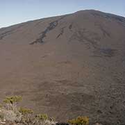
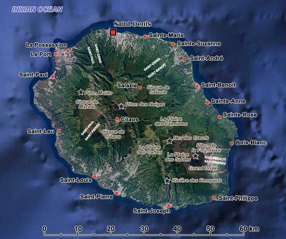
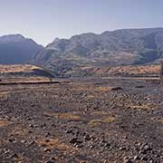
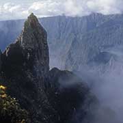
Réunion is a small volcanic island, about 175 kilometres south-west of Mauritius and almost 700 kilometres east of Madagascar, part of the Mascarene Islands in the Indian Ocean. It is 63 kilometres long and 45 kilometres wide, with an area of 2,512 km². The island emerged about three million years ago, with the Piton des Neiges volcano, 3,070 metres altitude, the highest peak in the Indian Ocean. To its east, the Piton de La Fournaise emerged about half a million years ago and is considered one of the most active volcanoes on the planet. The island has a very mixed population of almost 900,000. Officially, it is an overseas department and region of France that maintains a significant military presence on the island.
The island was uninhabited, possibly visited by Arab traders and Malay or Swahili sailors, but was first discovered by Europeans around 1597 when Portuguese explorers sighted it; the Mascarene islands were named after their leader Dom Pedro Mascarenhas; the present Réunion island was named Santa Apolónia by them. In 1638, the island was visited by French sailors who laid claim on it, and in 1642, it was officially claimed by Jacques Pronis, a French colonial administrator who deported twelve mutineers from Madagascar and left them there for five years. As they had survived, the island was deemed inhabitable, and it was then claimed by France for a third time and named “Île Bourbon” after the French royal House. In 1665, the French East India Company sent the first settlers to start colonisation of the island.
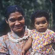
From the 17th to the 19th centuries, the French developed coffee and sugar plantations with slave labour, importing Africans, Chinese and Indians as workers, leading to the ethnic diversity of today. Slave traders from Madagascar raided the nearby Comoro islands and East Africa, while Arab traders bought slaves from Mozambique from the Portuguese. About 80,000 enslaved people were imported to the island of Bourbon until 1793 when the French Revolution broke out. The island was renamed “La Réunion” (meaning “meeting” or “assembly”), possibly to commemorate the meeting of revolutionaries in 1792 and the establishment of the States-General. However, there are no documents to verify this. Although slavery was declared abolished by France, Réunion rejected this, as did Île de France (Mauritius), from where Réunion was administered. Napoleon Bonaparte, who had become the First Consul of the French Republic, made slavery legal on the islands in 1802; the island changed its name again to “Île Bonaparte” on 26 September 1806.
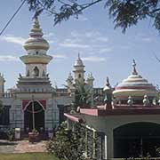
In 1810, during the Napoleonic Wars, the island was invaded and captured by the British Navy, as was the case in Mauritius. It remained under British rule until 1814 when it was returned to the French under the Treaty of Paris. Slave trading resumed: during the 1820s, around 2,000 slaves were imported monthly, mainly from the Arab Swahili coast or Quelimane in Portuguese Mozambique. It lasted until 1848, when slavery was finally abolished, 60,000 enslaved people were freed, and Bourbon Island was again named “La Réunion”. Slavery was now replaced by contract labour, although the illegal slave trade still persisted via the Comoro islands, but the trafficked Africans were officially called “engagés” (committed) workers. Indentured workers also arrived, contributing even more to the mixed population.
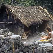
In the late 1800s, there were several economic crises, and the island became less important as a stopover for commercial traffic from Europe after the Suez Canal opened in 1869. Sugar cane also became less profitable as Europe started to use sugar beet that could be grown locally there. The settlements and farms had all been along the coast, while the interior was steep and without access roads. There had been escaped slaves (“maroons”) who settled in ”Les Hauts”, the high country. During the 19th century, also marginalised, landless semi-nomadic whites (called “Petits Blancs”, sometimes named “Yab”) gradually settled on occupied land. Of the three “Cirques”, the calderas leading down from the central mountain, the 3,070-metre high Piton des Neiges, were gradually administered to control the population in the 1830s and 1840s. Salazie became a commune, and land could be acquired, while in Cilaos and Mafate, food crops and coffee could be grown. The Plains between the two volcanic peaks were the last areas to be colonised from the 1850s onwards.
Réunion was a French colony until 19 March 1946, when it became a “Département d’outre-mer” (overseas département) of France. As a result, it has a similar status to its counterparts in Metropolitan France, is one of the furthest regions of the European Union, and is part of the eurozone. The island is divided into four districts, clockwise: Saint-Denis, Saint-Benoît, Saint-Pierre and Saint-Paul. Towns are along the coastal fringe, with the Plaine des Palmistes and Plaine des Cafres the flattest parts of the island; the rest has very steep terrain. It is a fantastic place for its mountain scenery and tropical beaches - a unique tropical island.